Popular Middle Fork American River Rafting Trips
The Middle Fork of the American is a fantastic river which has earned a reputation for its challenging whitewater and beautiful scenery.
The river includes some difficult and even dangerous rapids, and the river canyon is remote. No matter the time of year, boaters on the Middle Fork of the American should be mentally and physically prepared for self-rescue in the event of a swim. Private boaters should be confident in their abilities to run difficult rapids such as Tunnel Chute and Kanaka Falls.
For aggressive beginners and intermediate boaters, rafting the Middle Fork of the American with a commercial outfitter is always an option.
Ralston Powerhouse to Greenwood Creek
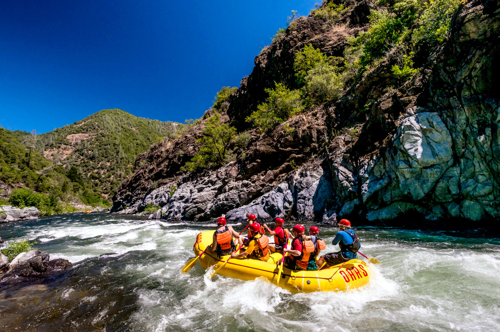
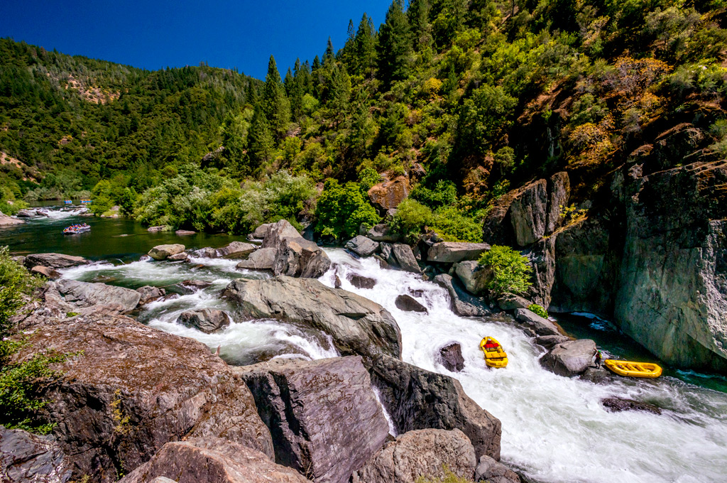
This 15 mile stretch of whitewater is the most popular for Middle Fork American River rafting. It includes the famous Tunnel Chute Rapid (V), which was created when miners blasted their way through the mountainside in the search of gold. Other exciting rapids include Kanaka Falls (IV), Upper Ruck-a-Chucky (III-IV), and Parallel Parking (IV).
It is worth noting that this section of the Middle Fork of the American River does have approximately 9 miles of Class I-II whitewater in the middle of the trip. If you are a hard-core adventure seeker, you might find this section a little boring. However, it is a great scenic section of river for eating lunch and picking blackberries; you can also hike up the tributaries for hidden swimming holes and more beautiful scenery.
Greenwood Creek to Mammoth Bar
The 6 miles between Greenwood Creek and Mammoth Bar are filled with numerous Class I-II rapids which are excellent for novice and intermediate boaters.
Make sure to catch the Mammoth Bar take-out, which is just above Murderer’s Bar Rapid. While Murderer’s Bar got its name from Gold Rush history, the rapid is also deadly and should be avoided at all costs. If you choose to continue on, you can portage on either side.
Please note that access to Mammoth Bar is regulated by Federal and State laws. From April 1st to September 30th, access is allowed on Sunday, Monday, and Thursday from 8:00 AM until Sunset. For more information, visit the Auburn SRA webpage.
Mammoth Bar to Highway 49 Bridge
This two-mile stretch is often added onto the Greenwood Creek to Mammoth Bar section, especially when access to Mammoth Bar is limited by the Auburn SRA. It begins with the Class V rapid named Murderer’s Bar, which is a required portage. While Murderer’s Bar got its name when gold seekers were killed by local Indians, the rapid has also caused the death of many boaters.
After Murderer’s Bar, there is one enjoyable Class III rapid. The takeout is at the Highway 49 bridge.
Mile by Mile Guide
| Mile 0 | Oxbow Bend Put-in. Put-in for most trips. The trip begins in the eddy just below the Oxbow Powerhouse. This uninhabited, pristine wilderness area was once home to two mining camps and more than 10,000 people. |
| ALARM CLOCK (aka GOOD MORNING! RAPID) (III). As its name implies, this rapid is the wake-up call for the day to come. | |
| Mile 0.2 | The North Fork of the Middle Fork enters the river on the right. |
| Mile 1.4 | LAST CHANCE RAPID (II). Stop at the eddy on the right bank to scout Last Chance and Tunnel Chute. |
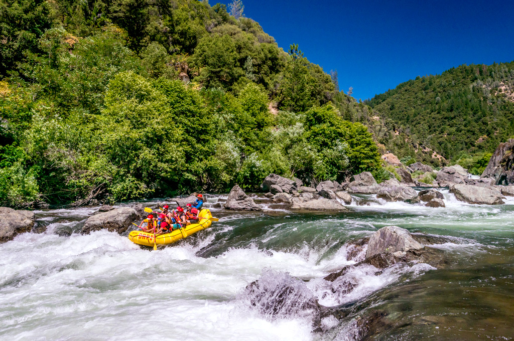
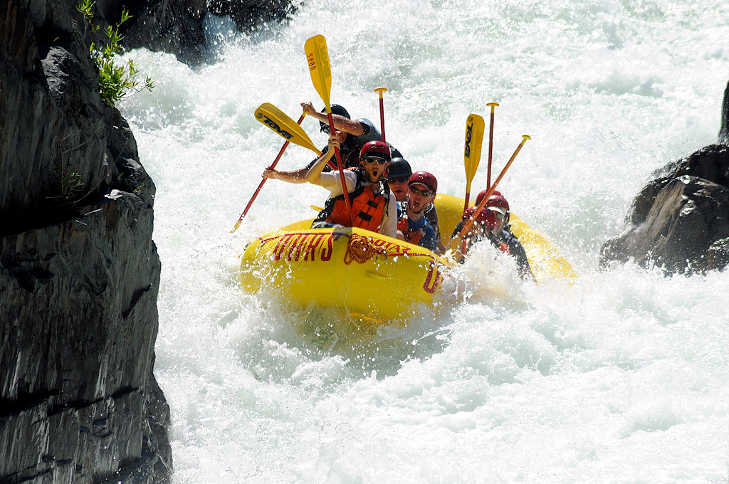
| Mile 1.5 | TUNNEL CHUTE (V). Recommended portage if you are unfamiliar with the rapid; easy portage on river left. Technically, the rapid should be called Chute Tunnel, as you will descend through a narrow 80-foot long chute which concludes with a big drop into frothy, churning water. You will then pass through a 90-foot long underground tunnel.This rapid was formed when crowds of miners came to the Middle Fork American River canyon in search of gold in the late 1800s. They realized that gold probably settled into what was formerly a slow-moving, horseshoe bend in the river. To divert the flow and access the hidden gold, they blasted a tunnel and dug a chute to guide the water through the tunnel. This alteration to the river created one of the biggest gold discoveries in the California foothills.There are numerous Class III rapids until the Class IV Kanaka Falls rapid. |
| Mile 2.0 | Volcano Canyon, river right. Josephine Canyon, river left. There was once a great deal of mining activity in this area. |
| Mile 4.1 | KANAKA FALLS (IV). The river rushes to the right over boulders, and the current will sweep the boat toward a rock wall on the right.The following nine miles of Class I-II rapids will provide opportunities for swimming and enjoying the Sierra Foothill scenery. |
| Mile 5.9 | Dardanelles Creek. A short hike up the creek offers hidden pools and waterfalls. |
| Mile 7.5 | Doodlebug Dredge. Historical gold-mining landmark. This gold dredge was once located more than 2 miles upstream. When the Hell Hole Coffer Dam broke on a tributary located even further upstream, a wall of water 80 feet high rushed down the canyon, picked up the Doodlebug Dredge, and deposited it here. |
| Mile 10.2 | Ford’s Bar, Otter Creek, river left. There is a side hike one mile up Otter Creek. There is a swimming hole and plenty of ripe blackberries from mid-July to August. |
| Mile 13.1 | Canyon Creek, river left. Emergency toilets are located above the sandy breach on the right. |
| Mile 13.2 | UPPER RUCK-A-CHUCKY (aka CHUNDER) (IV). Originally named by the gold miners in the 1800s, this rapid includes a fun six-foot drop. Scouting is recommended on river right. This rapid is best run above 1,000 CFS to avoid hitting a partially submerged boulder. |
| Mile 13.3 | RUCK-A-CHUCKY (VI). Recommended portage. This rapid is formed by a narrow sieve which passes between boulders, which drops over a steep and dangerous gradient. Easy portage on river right. This rapid was created in 1939 when the Army Corps of Engineers caused massive rock slides while attempting to build a dam. |
| Mile 13.5 | CLEAVAGE RAPID (III-IV). Run left of center to avoid a strong hole on river right. |
| Mile 13.7 | PARALLEL PARKING (IV). Enter between the two large boulders. Boats that miss the entrance can flip or wrap on rocks downstream. After the entrance, follow the diagonal chute from center to left. |
| Miles 13.8 – 15 | Numerous Class III rapids. |
| Mile 15 | Greenwood Bridge Put-in / Take-out. River right. Most common take-out for the Middle Fork of the American. A set of wide stone steps leads up to a parking lot. |
| Mile 16 | RECYCLE RAPID (II+). The river turns right to drop over ledges. Avoid midstream boulders at the bottom of the rapid. Catch the eddy on river left to surf in the great hole at the bottom of this rapid. |
| Mile 17.7 | The American Canyon creek joins the Middle Fork of the American on river left. This was the site of a large settlement during the gold mining era. There are good swimming holes and a scenic waterfall if you hike upstream. |
| Mile 17.8 | SPEED BUMPS (aka FUZZY BUNNY) (II+). The river turns to the left, drops over a few ledges, and turns into splashy waves and hydraulics. |
| Mile 18.5 | Maine Bar creek on river left. |
| Mile 19.0 | Buckeye Bar. A stark white chert formation on river right resembles the profile of George Washington. |
| Mile 21.6 | Mammoth Bar Take-out. River right. Take out here to avoid the dangerous rapid below! |
| Mile 22.0 | MURDERER’S BAR RAPID (V). Important to portage around! Dangerous boulder-strewn rapid with probably sieves. Portage on either side of the river. |
| Mile 23.7 | HEAVEN’S GATE aka J-TURN (III). This rapid is just above the confluence of the North and Middle Forks of the American. Scout or portage on river right. Line is down the chute on the right, into the pool, and then down the chute on the left; the hard move is to make it from right to left in time. |
| Mile 24.0 | Confluence of the North and Middle Forks of the American. |
| Mile 24.1 | Highway 49 Take-out. River right. Last good take-out before the Auburn Dam construction site. |
Rapid Classification via American Whitewater
| Class I | Fast moving water with riffles and small waves. Few obstructions, all obvious and easily missed with little training. Risk to swimmers is slight; self-rescue is easy. |
| Class II | Straightforward rapids with wide, clear channels which are evident without scouting. Occasional maneuvering may be required, but rocks and medium-sized waves are easily missed by trained paddlers. Rapids that are at the upper end of this difficulty range are designated “Class II+”. |
| Class III | Rapids with moderate, irregular waves which may be difficult to avoid and which can swamp an open boat. Complex maneuvers in fast current and good boat control in tight passages or around ledges are often required; large waves or strainers may be present but are easily avoided. Strong eddies and powerful current effects can be found, particularly on large-volume rivers. Scouting is advisable for inexperienced parties. Injuries while swimming are rare; self-rescue is usually easy but group assistance may be required to avoid long swims. Rapids that are at the lower or upper end of this difficulty range are designated “Class III-” or “Class III+” respectively. |
| Class IV | Intense, powerful but predictable rapids requiring precise boat handling in turbulent water. Depending on the character of the river, it may feature large, unavoidable waves and holes or constricted passages demanding fast maneuvers under pressure. A fast, reliable eddy turn may be needed to initiate maneuvers, scout rapids, or rest. Rapids may require “must” moves above dangerous hazards. Scouting may be necessary the first time down. Risk of injury to swimmers is moderate to high, and water conditions may make self-rescue difficult. Group assistance for rescue is often essential but requires practiced skills. Rapids that are at the lower or upper end of this difficulty range are designated “Class IV-” or “Class IV+” respectively. |
| Class V | Extremely long, obstructed, or very violent rapids which expose a paddler to added risk. Drops may contain large, unavoidable waves and holes or steep, congested chutes with complex, demanding routes. Rapids may continue for long distances between pools, demanding a high level of fitness. What eddies exist may be small, turbulent, or difficult to reach. At the high end of the scale, several of these factors may be combined. Scouting is recommended but may be difficult. Swims are dangerous, and rescue is often difficult even for experts. Proper equipment, extensive experience, and practiced rescue skills are essential. Because of the large range of difficulty that exists beyond Class IV, Class 5 is an open-ended, multiple-level scale designated by class 5.0, 5.1, 5.2, etc… Each of these levels is an order of magnitude more difficult than the last. |
| Class VI | These runs have almost never been attempted and often exemplify the extremes of difficulty, unpredictability and danger. The consequences of errors are very severe and rescue may be impossible. For teams of experts only, at favorable water levels, after close personal inspection and taking all precautions. After a Class VI rapid has been run many times, its rating may be changed to an appropriate Class 5.x rating. |
Put-ins and Take-outs
Many of the put-ins and take-outs are managed by the Auburn State Recreation Area. Some areas also have limited hours. For detailed information, visit the Auburn SRA website.
No matter the time of year, boaters on the Middle Fork of the American should be mentally and physically prepared for self-rescue in the event of a swim.
Ralston Powerhouse (Put-In)
This put-in is just below where the Oxbow Dam releases water daily.
Hours: 7:00 AM – Sunset
Directions from Auburn: Take the Auburn-Foresthill Rd 17 miles to Foresthill. Turn right on Mosquito Ridge Rd. 2 miles after crossing the Circle Bridge, turn right at Oxbow Reservoir Rd. Take the second right fork (FR23) and follow to the river.
GPS Coordinates: 39.00610889, -120.74725519
Greenwood Creek (Put-in / Take-out)
You can put in or take out on river right, above the old Greenwood Bridge. This is the most popular take-out for the one-day trip on the Middle Fork of the American, as there are not many Class III or higher rapids downstream. However, some people put-in at this location, portage around Murderer’s Bar Rapid, and enjoy the Class II-III stretches of whitewater downstream.
Hours: 8:00 AM – Sunset, from April 16 – Oct 14. Closed from Oct 15 – Apr 15.
Day Use Fee for Driver’s Flat Parking: $10
GPS Coordinates: 38.96256403, -120.93208084
Driving directions: Follow I-80E out of Auburn, CA. Take the Auburn Ravine Rd Exit toward Foresthill; turn right onto Foresthill Rd and follow for 7.5 miles. Turn right onto Driver’s Flat Rd and follow 2.5 miles to the river. Driver’s Flat Road is a slow, narrow dirt road; use caution.
Mammoth Bar above Murderer’s Bar Rapid (Take-out)
This take-out is at the Highway 49 Bridge, just as Highway 49 turns south towards Coloma. The take-out is just downstream of the confluence of the North and Middle Forks of the American.
It is important to know that Murderer’s Bar Rapid is directly after the Mammoth Bar take-out. Aptly named, Murderer’s Bar Rapid is a Class V and should not be attempted under any circumstances. If you choose to continue on, you can portage on either side of the rapid.
Please note that access to Mammoth Bar is regulated by Federal and State laws. From April 1st to September 30th, access is allowed on Sunday, Monday, and Thursday from 8:00 AM until Sunset. For more information, visit the Auburn SRA webpage.
Day Use Fee for Mammoth Bar Parking: $10
Summer Hours: April 1 – Sept 30
Sun, Mon, Thurs Open 8:00 AM – Sunset
Tues, Weds, Fri, Sat Closed
Winter Hours: October 1 – March 31
Sun, Mon, Thurs, Fri Open 8:00 AM – Sunset
Tues, Weds, Sat Closed
Directions from Auburn: Take Highway 49 east out of the city. Just before crossing the bridge, turn left onto Old Foresthill Road and continue for 1.5 miles. Turn right onto Mammoth Bar Road and follow to the river.
Alternatively, you can take Highway 80 east out of Auburn. Take the Foresthill exit and turn right down Foresthill Road. Continue for 2.5 miles until you turn right on Old Foresthill Road. Turn left onto Mammoth Bar Road after approximately 1.5 miles.
GPS Coordinates: 38.920596,-121.003993
Highway 49 Bridge (Take-out)
This take-out is useful when you when you want an easier shuttle or when the Mammoth Bar take-out is closed.
Be careful to portage the dangerous rapid after Mammoth Bar, appropriately known as Murderer’s Rapid. Confluence Rapid is a challenging Class IV rapid, located just above the confluence of the North and Middle Forks of the American.
Directions from Auburn: Take Highway 49 east out of the city. Continue until Highway 49 crosses the Middle Fork of the American. Park just east of the bridge.
Day Use Fee for Confluence Area Parking: $10
Hours: 7:00 AM – Sunset
GPS Coordinates: 38.91612724, -121.04028652
Private Boating Permits
Private boaters are not required to obtain a permit to raft the Middle Fork of the American River. However, those planning to camp overnight on the banks of the river are required to purchase a wilderness camping permit.
Riverside Camping Permits
Boaters who intend to camp overnight on the banks of the Middle Fork of the American River are required to purchase a wilderness camping permit. Permits are managed by the Auburn State Recreation Area. For more information or to obtain a permit, call (530) 885-4527.
Fees: Primitive Campsite $15
Extra Vehicle $5
It is important to note that some land along the Middle Fork of the American is privately owned. Boaters should be careful to camp only on public land. Many popular public campsites are located between Kanaka Falls and Upper Ruck-a-Chucky Falls.
Photography
There are two main companies which take photos on the Middle Fork of the American River. Photographers are usually located at Tunnel Chute. You can order your photos online, or you can call to speak to a representative.
(530) 621-0400
7308 Hwy 49, Unit E
Lotus, CA 95651
Book with a Commercial Outfitter
Are you excited about a Middle Fork American River rafting trip, but not ready to do it on your own? Or are you trying to avoid the hassle of organizing a trip on your own?
There are more than 20 permitted outfitters on the Middle Fork of the American River. Based in California, OARS is among the most experienced and offers a variety of trips throughout the western U.S., from half-day excursions to 18-day expeditions. To schedule a Middle Fork American River rafting trip with OARS, visit http://www.oars.com/california/middleforkamericanrafting.html or call 1-800-446-7238.